A Quick Trip to the Northern Plains
Lodging Review: Home2 Suites by Hilton Rapid City, SD
Our Visit to the Crazy Horse Memorial and Custer State Park
Our Visit to Mount Rushmore and Theodore Roosevelt National Park
Lodging Review: TownePlace Suites, Dickinson, North Dakota
Lodging Review: Fairfield Inns & Suites, Chicago O’Hare
After a lunch break in the small town of Custer, which is right outside the Custer State Park, we continued our loop toward Mount Rushmore. By early afternoon the the sky had darkened and the wind had picked up but it wasn’t too cold. But that would change in the 40 minute drive to Mount Rushmore.
The route to Mount Rushmore from Custer is primarily on a two-lane road that goes up and over some of the Black Hills in the region. Though I knew that the presidents’ faces were carved high up on a mountain I just assumed that the only way to view them was to actually enter the National Monument area. It hadn’t occurred to me that there may be other vantage points from which the faces could be seen. Taking the route we did, we happened upon one of those points. There was a small parking lot along with trail indicators. Walking to the end of the short trail there’s actually a very nice view of Mount Rushmore. Again I wished I’d already upgraded my phone just to get better photos!
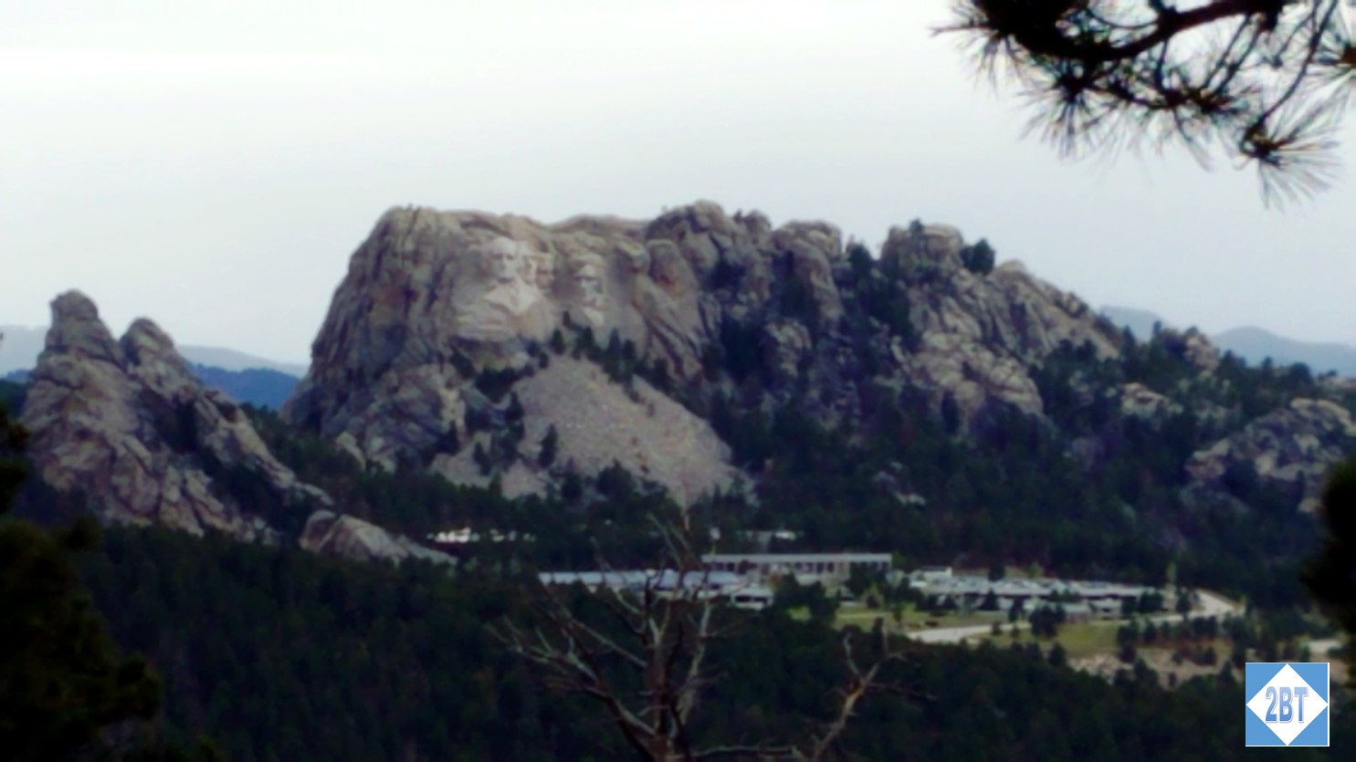
Mount Rushmore from afar
Mount Rushmore
From there we continued our drive to the National Monument site. The tickets you buy there are good for a year which means you can make multiple visits on a single trip to the area. That’s something we made use of. There’s a multi-level parking deck though we were able to park quite close because by the time we arrived (around 2:30 PM when the wind advisory was supposed to be ending), the wind had actually increased, there was a bit of sleet and the air temperature had dropped into the upper 40sF meaning the wind chill was quite below that! On the photos we took with the monument we’re all bundled up in winter coats with winter hats on our heads. We almost felt sorry for the folks who hadn’t paid attention to the weather forecast and were outside in shorts, t-shirts and sandals. Let’s just say the gift shop did a brisk business in sweatshirts and jackets while we were there!
While I am sure there are ways for the mobility-challenged to avoid all the stairs that we took, I did notice that there were a surprising (to me) number of steps between the parking deck and the main path of the memorial. I suppose that with the winter weather that steps are actually safer than ramps and none of the steps were steep or tall but there were quite a number of them.
Once you reach the memorial site, there’s a wide center path leading to the Avenue of the Flags which leads right up to the memorial’s viewing platform. There’s a flag for each state and a number of US territories. The flags were whipping wildly during our visit with some of them getting tangled up around their flag poles.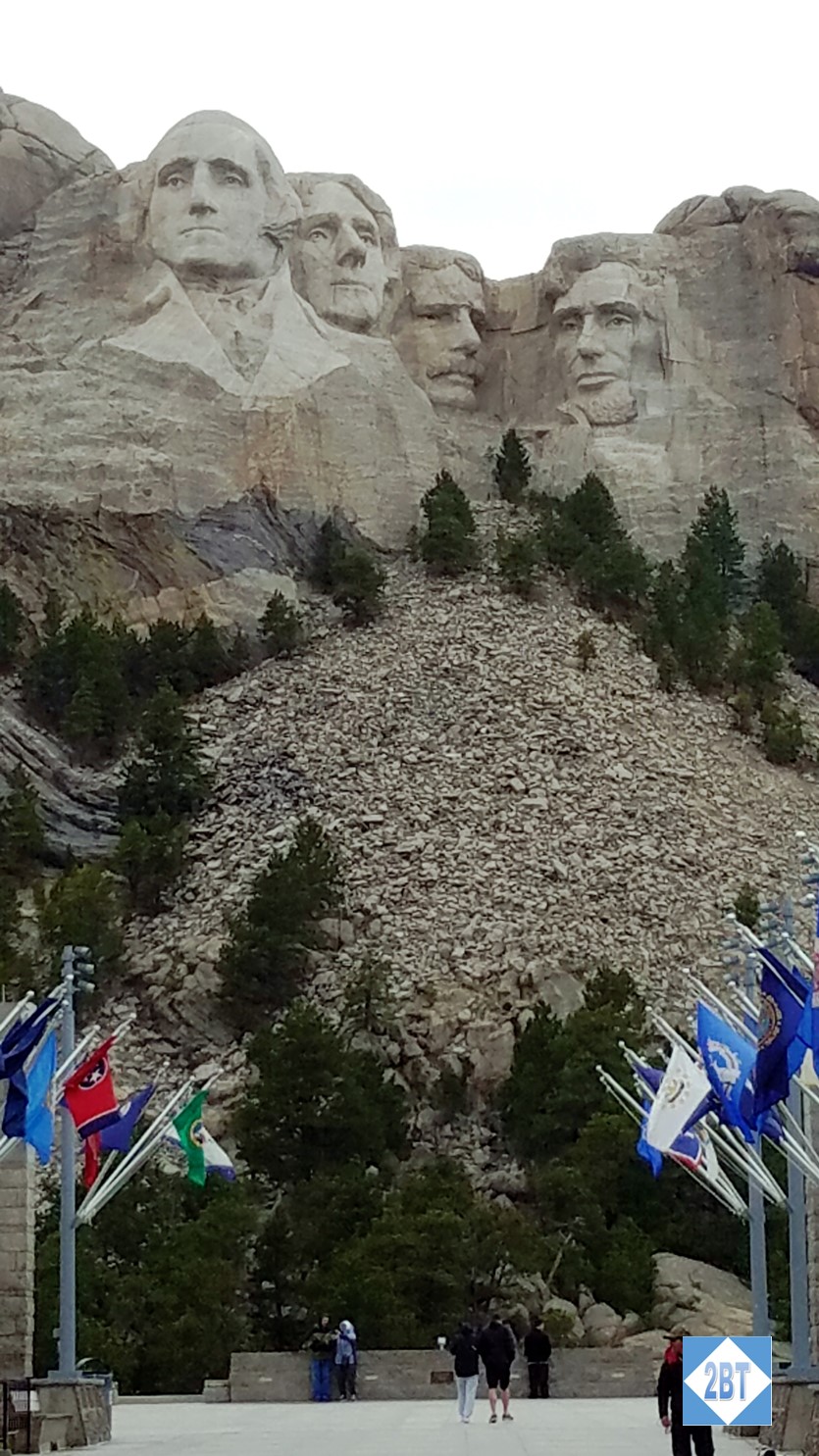
And then, there we were, in front of George, Tom, Teddy and Abe. Pretty amazing stuff. What I didn’t realize is that down below the viewing area at the base of the mountain is a fairly large amphitheater. I’m told concerts take place there on holidays and such. If I didn’t dread the crowds so much I think that would be a pretty cool place to celebrate July 4th.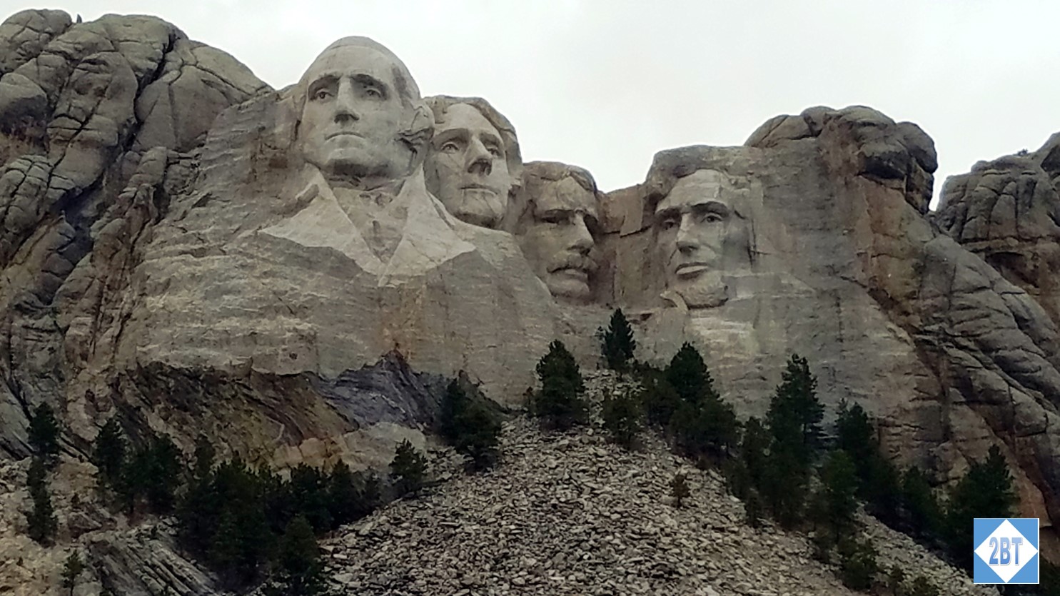
Since our tickets were good for a year, I persuaded my friends to come back at night to see the monument under the lights. As we were only about a month away from the summer solstice the sky didn’t get really dark until after 9 PM but it was dark enough to enjoy the different view, I thought. The wind had finally calmed down which made for a more pleasant viewing experience!

Somehow I think Abe looks a bit surprised all lit up!
Driving to North Dakota from Rapid City, SD
On the map it appears that the drive from Rapid City, SD to Theodore Roosevelt National Park in North Dakota is pretty straightforward. What the map doesn’t tell you is that it’s mostly 2-lane highway wandering through farm country, sometimes involving barely-paved roads. To be fair, we saw 18-wheelers on these roads too so it wasn’t like we were lost, it’s just that there’s not a good 4-lane highway between the two areas. Depending on how often and how long you stop, it’s a 3h 45m to 4-hour drive from Rapid City to the park entrance. There are a few slow zones but really we were able to make good time, considering.
Theodore Roosevelt National Park
The park is unusual in that it is divided into three sections: the North Unit (entrance along US 85), the South Unit (entrance along I-94) and the Elkhorn Ranch Unit which is accessible from Forest Service Roads. Another distinction: the North Unit is on Central Time while the South Unit and Elkhorn Ranch Unit are on Mountain Time! The three units are distinct from one another and you cannot drive among them and stay in the park. The Elkhorn Ranch Unit is the remains of Roosevelt’s second ranch and there are no buildings or services in this part of the park. The roads are unpaved, steep and can be washed out by floods. The North Unit has a 14-mile scenic drive, herds of Longhorn Steers and overlooks of the Little Missouri River and its floodplains. Unfortunately we did not have time to see any of these!
Our time was spent in the South Unit. We first stopped at the Painted Canyon Visitor Center which is its own exit (#32) off I-94. There’s a nice gift shop and clean facilities. There’s also a nice overlook of the Painted Canyon and the trailhead of the Painted Canyon Trail, which connects to several others in the South Unit.

Painted Canyon in Theodore Roosevelt National Park
After taking a few photos there, we hopped back in the car and headed five miles west on I-94 to the small town of Medora, where the South Unit entrance and Visitor Center are located. The South Unit has a 36-mile scenic loop drive. Unfortunately the latter part of the loop was closed due to road repairs but we got around much of it, stopping as we saw things of interest on the way out and then driving straight through on the way back.
From the Skyline Vista viewing area, looking back toward I-94. The last photo shows some of the feral horses that live in the area:
Sites from the Wind Canyon overlook. That’s the Little Missouri River making a big turn:
The topography of the Badlands is like nothing I’d seen before and I found it beautiful. All the strata of rock and soil exposed to the elements. When asked to describe it, I say in some sense it reminds me of areas like the Grand Canyon except that there the colors are reds, oranges and browns and it seems more rocky and sharp edges. The Badlands has more greens, tans and browns with rounded edges. I found it fascinating. The first (darker) photo below is from the Boicourt Overlook while the other two are from the Badlands Overlook:
Though we had light rain off and on the whole time we were in the park, we were fortunate that at all but one of the places we wanted to get out and look around it stopped raining while we were doing that.
If you want to hike in the park there are lots of trails. From what I saw none looked to be super-hard although there were certainly hills in play and there may very well have been difficult sections I couldn’t see. Everywhere in the park we went, even outhouses, I was impressed with the cleanliness of the restrooms. None of that typical smell. Of course the coolness of the weather may have factored into it but it was a pleasant surprise. There are overlooks that can be accessed by wheelchair and many things – including several prairie dog towns – can be seen right from the road but several of the scenic overlooks require a short hike over uneven trails.
While I’m not one for camping I would love to come back and hike some of the trails. There are bison and wild horses that roam freely and I think it would be amazing to be walking in their territory, at an appropriate distance, of course!
In the end
From the man-made carvings of Mount Rushmore to the natural beauty of the Badlands, I thoroughly enjoyed our two days in the Dakotas. Mid-May can be an iffy time of the year with the weather but even the coldest we experienced wasn’t terrible and I much prefer touring in this type of weather vs. hot sun and tons of tourists. I would love to go back to the area for a few days maybe in September some year and see what the fall colors look like in the Badlands.


Recent Comments